

Rain. That’s what we will see over the next 48 hours or so, and we will be seeing a lot of it.
“Significant and potentially historic flooding,” was said to be with this incoming system by the National Weather Service office in North Webster. Four to five inches of rain is expected area wide, with some areas that could see closer to six inches.
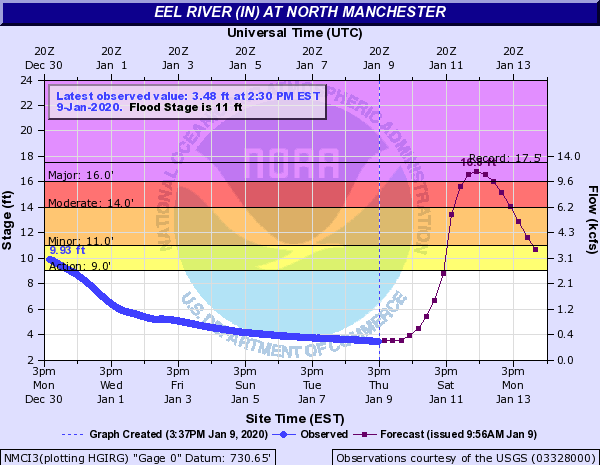
On Thursday afternoon, just before 2 PM, the weather service issued 24 river flood warnings simultaneously for various river basins in the area. Included in that was the Eel River in North Manchester, which is forecast to crest at 16.8 feet around 3 PM on Sunday afternoon.
That would put the river into a “major flood stage,” which according to the NWS website, would create “significant flood problems in southwest Whitley and northeast Wabash Counties” and flood waters would be reaching homes and businesses in North Manchester along South Mill Street. The 16.8 feet would tie it with the third highest crest on the river from 1990 and less than a foot away from the all-time record flood level of 17.5 feet set back in March of 1913.
Warning Coordination Meteorologist Michael Lewis says this winter has been “crazy” so far with temperatures being well above normal and it has been an incredibly wet season. “The situation is interesting because the ground is somewhat frozen, warming up a little bit, but we’re looking at it and treating this like the ground is frozen. There isn’t a lot of field work, so the water will saturate the ground very quickly and run off after that.”
Lewis said the rains early on Friday won’t see too much of an impact on flooding, but late Friday and into Saturday is when the heavier rains will come in. “We are looking at several bands of pretty significant, intense heavy rainfall on already saturated ground, and it’s just going to run off. Our big concern is flooding. It’s not an easy situation but that’s the reality.”
The Tippecanoe River is also expected to rise into flood stage, and that could create flooding in areas of Warsaw, along with North Webster, Oswego, and other open areas along the river into western Kosciusko County and those areas in Marshall and Fulton Counties.
Another concern earlier in the week was the wintry precipitation that was forecast, but the wintry impact is not supposed to be as bad as first thought. Lewis says rain will change over to some sleet and snow, but maybe a light dusting is expected to fall. “With the ground wet and as much rain as we’ve gotten, the chance of that accumulating on the surfaces is little, if any. Even with the winds coming in, the ground will be relatively warm (to prevent accumulation).” While the snow may not pose an issue, he said overpasses and exposed areas could see some ice, but he isn’t expecting a big ice issue.
Lewis mentioned that if this were to be a system bringing in snow, the water equivalency would make for a winter wonderland. “Given the pattern we are in, and if it was cold enough, we could have seen 18 to 20 inches of snow given with the amount of moisture that’s in the air. But if it were colder than it has been, you wouldn’t have this much moisture in the air. Instead of the four inches of water, we’d probably see one to two inches of water.”
“It all plays against each other, the atmosphere is crazy.”
The weather service says to keep an eye on their Facebook page or the IWX website for updates during the rains. With the flooding potential, they advise safe driving out on the roads and use the phrase, “Turn around, don’t drown.”


