

By Dan Spalding
News Now Warsaw
WARSAW — Friday’s weather in Kosciusko County, which included a mix of rain, sleet and heavy wet snow, is being replaced by a blast of arctic air on Saturday that is stretching across the central part of the country.
Meanwhile, conditions north of Kosciusko County, including South Bend and Niles, Mich., are considerably worse, and the National Weather Service has issued a winter storm warning in that region until 7 p.m. Saturday.
The snow and slush that made for difficult driving conditions across the region Friday has now turned to icy conditions across the region.
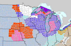
The National Weather Service has a winter weather advisory in place in Kosciusko County until 7 p.m. Saturday and warns motorists should plan on slippery road conditions. Patchy blowing snow could significantly reduce visibility. Gusty winds could bring down tree branches, the weather service said.
Winds on Saturday will remain gusty and could exceed 45 mph at times.
Windy conditions have been resulting in some sporadic power outages. As of 6 a.m., NIPSCO was reporting about 293 outages across north central Indiana, including 19 in Pierceton and 14 in Nappanee.
A wind chill advisory is in effect from midnight Saturday to 1 p.m. Sunday.
Overnight temperatures were in the mid-20s and Meteorologist Matt Rudkin predicts temps will slowly fall all day long and will be near zero by 7 a.m. Sunday.
Wind chills by nightfall are expected to be around 25 below zero.
Light snow is possible through the morning hours, according to Rudkin.


