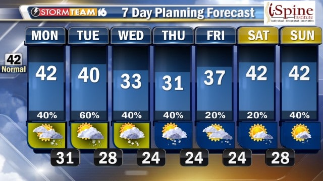
The next wintry weather system moves late Monday, March 5, bringing more clouds and late afternoon and evening rain.
WNDU Meteorologist Cindi Clawson reports a system coming out of the Plains will bring a slight chance for rain and snow, with much better chances for rain, and snow more likely on Monday night.
Most areas north of U.S. 30 should see 1 to 3 inches of snow with lesser amounts south of U.S. 30.
Rain and snow will be possible on Tuesday, though probably more snow than rain, with only minor accumulation expected.
Cooler temperatures continue through the week with rain and snow chances continuing, including a chance for lake-effect snow Wednesday and Thursday.
We should start to dry out by Friday.
Hazardous Weather Outlook
From the National Weather Service of Northern Indiana

This hazardous weather outlook is for portions of southwest
Michigan...northern Indiana and northwest Ohio.

MONDAY THROUGH SATURDAY

Rivers are expected to slowly recede this week.

Some light snow accumulations are possible at times throughout much
of this upcoming week. Roads may become slippery especially at night
and early in the morning during these times.


